Is this the world's remotest Strava KOM? I smuggled a folding bike onto a dinghy just to get there
A quest to ride a rarely used climb on a tiny island in the Atlantic, lead one rider to an abandoned archipelago, armed with a crafty stowaway
Over the past decade, I've become obsessed with going uphill as fast as I can. Having drifted from road racing into hill-climbs, I now relish pushing myself to the absolute limit on steep gradients. That buzz of riding through raucous crowds at events like the National Hill-Climb Champs, feeling like a pro rider on a mountain stage of the Tour de France, cannot be beaten.
Living a stone's throw from the Peak District, I've spent hours plotting saw-tooth-profiled routes locally, but more recently I've started seeking out new climbs in unfamiliar corners. That's where this story begins: a mission to find Britain's most undiscovered ascents, so remote they barely register on the map. After trips to Shetland and Orkney, my sights turned to the Highlands and Western Isles.
As a 45-year-old engineer with a wife and two children, juggling family commitments with trips away is often challenging. My training is shoehorned into whatever time I can find. These days, I'm focused more on exploration than competition, and with limited holiday, much of my year involves planning the intricate details of adventures. Finding esoteric hills to climb has become my raison d'être.
While scouring Google Maps as if it were a Goonies-style treasure map, I thumbed west across Scotland, the Outer Hebrides, and into a vast expanse of blue. Then I saw it: a speck in the Atlantic, 40 miles beyond the Isle of Harris, the last outpost before North America... St Kilda - an abandoned, windswept volcanic archipelago. And, crucially, a dashed line on the map running from the harbour to the summit of Mullach Mòr at a lofty 361m. Could it be a road? I dared to dream. If so, I might just have stumbled upon Britain's, or even the world's remotest KOM.
Looking closer at that dotted line, its stats were irresistible: 2.4km at an average of 14%, maxing at 22%, with 340m of elevation gain - a solid Category 2 on paper. It was calling me. The question was, how the hell could I get there?

The only way ashore onto St Kilda is by dinghy
St Kilda was inhabited for around 2,000 years, with the population peaking at about 180 in the 1600s. But life was harsh. Access was difficult and supplies unreliable, and by 1930 just 36 people remained before the islands were finally evacuated. Today, only military personnel occupy the archipelago, manning an MOD radar station atop Mullach Mòr to monitor missile tests.
A helipad brings in emergency supplies during winter, when boats often can't land. Even in summer, conditions are unforgiving: strong winds, gusts exceeding 100mph, swells over four metres, and sheer sea cliffs severely restrict safe landings. Somehow, I needed to find a way ashore - with a bike.
I spent hours plotting an ambitious plan: an eight-day trip in mid-August, chasing the best of the weather. The route would weave by road and ferry - Skye, the West Highlands, across to Lewis and Harris, out to St Kilda, then down through North and South Uist, Barra, and home via Tiree - all dictated by the tight, unforgiving timetables of Hebridean ferries.

The island of St Kilda sits far out in the Atlantic ocean
One major problem loomed: the boats to St Kilda. Sea Harris's 'Enchanted Isle', the largest available and built for Atlantic conditions, has limited storage. To protect the islands' seabird colonies, nothing larger than a dinghy is allowed to shuttle passengers ashore. Getting a full-sized bike onto it seemed unlikely and probably unsafe. My only option, I realised, was a folding bike.
After scouring the local ads, I settled on a £40 second-hand Raleigh Swift. It tipped the scales at 12.5kg, even after I had removed the rack, mudguards, prop stand and bell. No featherweight, then, but it would have to do. Folded into a modest holdall, the props were set - bring on the theatre.
St Kilda is the UK's only dual UNESCO World Heritage Site, owned by the National Trust for Scotland and shared with QinetiQ, which operates the MOD radar station on Mullach Mòr. I had no idea who owned the road, or whether I would be allowed to ride it. With vast colonies of gannets and puffins, would there be restrictions during nesting season, or oversight from on-site volunteers? I didn't know who to ask, and my attempts to contact the island went unanswered - so I settled on the simplest plan: turn up and beg.

Departure day was flawless: glass-smooth seas, a gentle breeze, and a cloudless sky. As the Harris 'butty' bus steamed beside the harbour, midges formed a halo around my coffee. I slung my bike over my shoulder and boarded; the skipper's mate didn't even blink, tossing my weighty metal package into the hold. No questions, no drama. Soon we were clear of the harbour, powering into the Atlantic at 20 knots.
We wove through a maze of lobster pots and fishing boats until the islands vanished behind us, leaving nothing but the open ocean and a solitary sea eagle circling overhead. Standing at the rail as spray kicked up, I felt like a modern explorer. Finally, after two and a half hours, the main island, Hirta, appeared in front of us, its summit shrouded in cloud.
The boat slowed to a halt and dropped anchor. As the first group zoomed towards the shore in the transfer dinghy, I prepped my gear. When my turn came, first my heavy stowaway was lowered in, then me, and off we set. Once on terra firma, the island's friendly ranger enquired about my cargo. "Oh, this? It's just my lunch," I joked, before summoning the courage to make the hardest pitch of my life.
'Three miles long by two miles wide' – read Cycling Weekly's adventures on Ireland's offshore islands.
Accessing the island's interior meant navigating more than just the terrain; I would need official clearance from QinetiQ, explained the ranger. Safety was the priority, especially with recent heavy rains triggering landslides. While the ranger contacted the on-duty crew, I explored the renovated settlement. Between the old school, church and museum, I traced a history stretching back to the Bronze Age.
It's a landscape defined by its birdlife - gannet, fulmar and puffin colonies once fuelled a rugged economy of feathers, oil and tweed. Dotting the hills are thousands of cleitean - unique stone storehouses that remain the architectural signature of this isolated archipelago. I was relieved when the ranger reappeared smiling and motioning a thumbs-up. I scrambled to build the bike and was soon ready to roll.

Rolling off the jetty to a chorus of cheers from day-trippers, I powered around the harbour while praying the road ahead would be rideable. The climb begins at a bridge near the boat slip, where the road tilts viciously skyward: straight to 6%, then 8%, then 12%. Bounded by drystone walls and dark crags, this was an ascent as picturesque as it was brutal.
Clicking desperately down through my six gears, I very soon found that the lowest ratio was a nowhere-near-low-enough 46/28. Forced out of the saddle, I lunged into a left-hander, followed by a brutal right-hand hairpin at over 20% incline. It was then I realised I'd made a fatal mistake: flat pedals.
With sit-up-and-beg handlebars and no ability to pull through the upstroke, I was forced to fight the bike rather than ride it. My back screamed; my legs burned. I just had to keep going. Failure was not an option, nor was dabbing a foot to the tarmac. Somehow, I made it to the top.
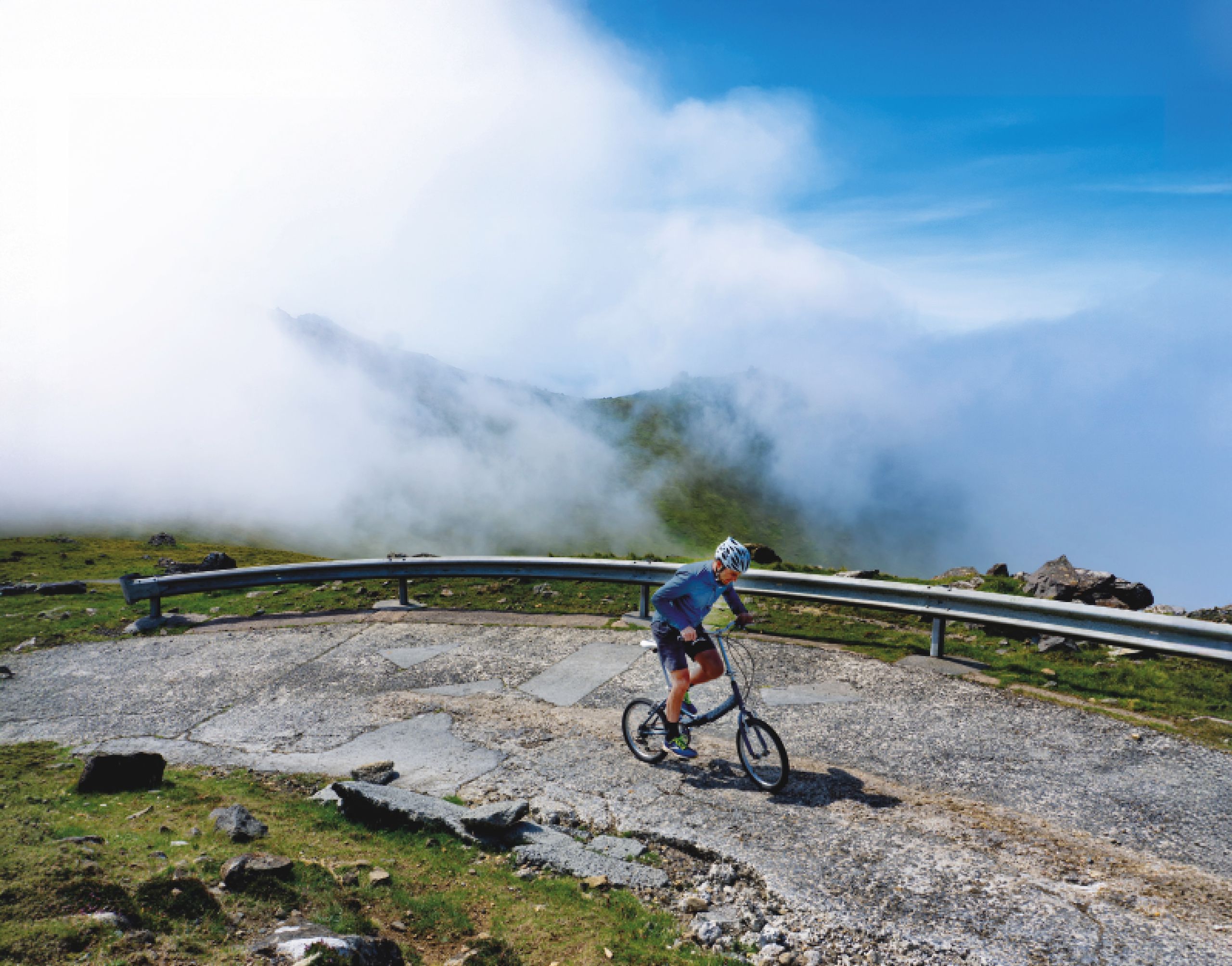
Turning around, a cloud inversion stretched before me - mist pouring over cliffs, spilling into the bay, and climbing the opposite slopes like slow-motion surf. It stole what little breath I had left. After a short loop of the transmitters, I began the descent through fields of cleitean.
Halfway down, I came upon a white pick-up crawling towards me. The driver wound down his window, grinning like a Cheshire cat. "How was it?" he asked. "Unbelievable," I said, and, struggling for words, asked if he'd ever seen anyone ride this road before. He stared back, bemused. "No one's that crazy!"
All around me, the cloud broke and I was gifted momentary glimpses of Hirta's jagged sister island, Soay, before it vanished back under a veil of mist. By the time I rolled into the village, relief had turned to joy, then pride. It was amusing to upload my ride to Strava and find myself one of only four who'd ridden this climb - let's just say I'm in the top three!
But this wasn't about Strava segments or KOMs. This adventure was about riding what may well be the most remote hill-climb in the UK: a peak on the edge of the world, shaped by wind, history and abandonment. And it's waiting for the next rider who's intrepid, or mad, enough to take it on.

The adventure culminates in triumph alongside the MOD radar station
How to get there
Most boat tours (kildacruises.co.uk; stkildaseatours.co.uk) leave from Leverburgh on the Isle of Harris at 8am, returning at 7pm. Passengers may be allocated a two-day weather window, allowing for inclement conditions, with confirmation given by 1pm the day before. It takes around three hours to reach Hirta, giving you four to five hours to explore before the return ferry departs.
Where to stay
The only option for visitors to stay on the main island, Hirta, is a small campsite which must be pre-booked (max stay five nights), which is open mid-April to mid-September: nts.org.uk. On the Isle of Harris, Grimisdale guest house and Am Bothan bunkhouse are good options in Leverburgh. I chose to camp at the picturesque Horgabost campsite.
When to travel
The main access window is April to September, with the best weather from June to August. If you want to ride Mullach Mòr, get permission from the warden - email [email protected].
What to take
Prepare for all seasons, and carry enough food and water for your entire trip. If taking a larger bike, enquire with the boat tour operator on stowage capacity. All bikes need to be packed in a bike carrier to avoid damage to the transfer dinghy.
This feature was originally published in the 9 April 2026 print edition of Cycling Weekly magazine – available to buy on the newsstand every Thursday (UK only) while digital versions are available on Apple News and Readly. Subscriptions through Magazine's Direct.